a single line on a map could determine the future of water in the Northern Territory
- Written by: Sue Jackson, Professor, Australian Rivers Institute, Griffith University
A water war is brewing[1] in the Northern Territory – and the battle centres around a line on a map.
Where the line is drawn determines how much groundwater is available for irrigation, mining and gas extraction. The line currently runs through the middle of the resource-rich Beetaloo Basin.
There are recent indications that the NT government will effectively move the line, potentially allowing for substantially more water to be extracted by gas and other industries.
This could cause long-term and irreversible damage to springs, wetlands and rivers upon which people and ecosystems depend.
A region rich in nature – and gas
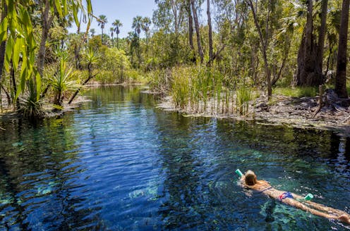
The Beetaloo Basin[2] lies around 500 kilometres southeast of Darwin. It’s in a region home to the abundant plant and animal life of the Roper River, Elsey National Park, Mataranka Springs[3] and Red Lily Lagoon, among other culturally and ecologically significant sites.
These ecosystems are fed by water stored beneath the surface in large aquifers, which are recharged by rainfall and seepage from rivers and lakes. Below these aquifers lie vast reserves of gas[4].
Under NT law, “water allocation plans” must calculate how much water can be extracted sustainably. However, such plans are only in place for 5% of the NT[5].
Elsewhere – where there is often great uncertainty about the impacts of groundwater extraction – water is licensed according to “contingent rules[6]”. These rules divide the NT into two zones: the top end and the arid zone.
The top end zone allows groundwater extraction of up to 20% of the water that replenishes the aquifer each year. The northern part of the Beetaloo Basin is in this zone.
The arid zone permits much higher rates of extraction: 80% of the aquifer’s total groundwater storage capacity can be extracted over a century, as long as dependent ecosystems are not harmed. The southern part of the Beetaloo Basin sits in this zone.
In arid zones, not much water flows into aquifers due to limited rainfall and high evaporation rates. Extracting a large proportion of water from these aquifers will inevitably reduce outflows to rivers and springs. Arid zones therefore need a much more cautious approach to water licensing.
There are now strong indications that the NT government intends to use arid zone rules in the top end zone – effectively moving the line between the two zones. Alarmingly, this would increase the amount of water that industry could extract from aquifers, including those sitting on top of Beetaloo gas reserves.
Enlarging the arid zone
A company called Territory Sands plans to mine 110 million tonnes of sand near the small NT town of Larrimah. The sand would be sold to gas companies operating in the Beetaloo Basin, for use in the fracking process.
The sand would have to be washed. To do this, Territory Sands wants to take up to 1.2 billion litres of water each year from the Mataranka Tindall Limestone Aquifer.
The aquifer is currently classified as being in the top end zone. But the NT Department of Environment, Parks and Water Security says[7] the aquifer could be considered as being in the arid zone.
Asked by The Conversation’s editorial team why this was the case, the department said extraction rules were “based on the behaviour and characteristics of the aquifer [a project] is drawing from” in accordance with a technical classification report[8].
Territory Sands has used the arid zone rule to calculate how much water it should be allowed to take. The Conversation attempted to contact the company for comment, but had not received a response at the time of publication.
Official documents show[9] the NT government is considering using the arid zone rule for future water extraction in the same area.
Environment groups have expressed concern[10] about the harm excessive extraction from the aquifer could cause. So too have some First Nations communities[11].
Read more: Water injustice runs deep in Australia. Fixing it means handing control to First Nations[12]
One of the NT’s most popular tourist attractions, the Mataranka thermal pools, depends on the Mataranka Tindall Limestone Aquifer. It also provides water for the Roper River, along which are many sites significant to[13] Traditional Owners.
The NT government has in the past tried to apply arid zone rules in the top end zone. In 2020, it used the same rule to grant a licence[14] to extract 10 billion litres of groundwater from the same aquifer.
This is despite a senior NT water bureaucrat warning[15] it would threaten permanent flows to the Roper River.
The NT government withdrew the licence after an independent panel found using aquifer storage as a basis for assessing licences was not precautionary or sustainable.
In a statement provided to The Conversation’s editorial team, the department said there were a number of aquifers and management zones in the Mataranka and Larrimah area – some arid and most top end.
“The specific characteristics of these resources as well as the required environmental and cultural protections, determine how they are managed under a plan,” the statement said.
The department said springs, rivers and wetlands were features of a top end system, so arid zone rules would not apply to them.
Shifting the burden of harm
The arid zone rules are deeply problematic. In recognition of this, the 2017-18 Pepper Scientific Inquiry into Fracking[16] cautioned against using the rules in the Beetaloo, finding it would be “ecologically unsustainable”.
Using water storage volumes to calculate sustainable yield is out of step with sustainable management practices[17] in other Australian jurisdictions and many parts of the world.
In arid zones, it’s not possible to avoid harm[18] to groundwater-dependent ecosystems if most water stored in an aquifer is extracted. Doing so inevitably reduces, or stops entirely, groundwater flows to the surface environment.
And aquifers take time to adjust to changes. So the 100-year time frame that applies under the arid zone rule shifts the burden of harm into the future. If new permits are issues to projects that deplete the aquifer, long-term damage is locked in.
Water extraction in the Northern Territory must be scientifically defensible. Otherwise, future generations and the ecosystems that depend on the water will suffer – and the damage may be irreversible.
Read more: Hidden depths: why groundwater is our most important water source[19]
References
- ^ is brewing (www.abc.net.au)
- ^ Beetaloo Basin (www.aph.gov.au)
- ^ Roper River, Elsey National Park, Mataranka Springs (publications.csiro.au)
- ^ vast reserves of gas (www.abc.net.au)
- ^ place for 5% of the NT (www-tandfonline-com.libraryproxy.griffith.edu.au)
- ^ rules (depws.nt.gov.au)
- ^ says (www.abc.net.au)
- ^ report (territorystories.nt.gov.au)
- ^ show (depws.nt.gov.au)
- ^ expressed concern (www.abc.net.au)
- ^ First Nations communities (www.abc.net.au)
- ^ Water injustice runs deep in Australia. Fixing it means handing control to First Nations (theconversation.com)
- ^ sites significant to (www-tandfonline-com.libraryproxy.griffith.edu.au)
- ^ grant a licence (www-tandfonline-com.libraryproxy.griffith.edu.au)
- ^ warning (www.theguardian.com)
- ^ Pepper Scientific Inquiry into Fracking (frackinginquiry.nt.gov.au)
- ^ practices (pubs.er.usgs.gov)
- ^ harm (iopscience.iop.org)
- ^ Hidden depths: why groundwater is our most important water source (theconversation.com)