The wild weather of La Niña could wipe out vast stretches of Australia's beaches and sand dunes
- Written by: Javier Leon, Senior lecturer, University of the Sunshine Coast

Australians along the east cost are bracing for yet another round of heavy rainfall this weekend, after a band of stormy weather soaked most of the continent[1] this week.
The Bureau of Meteorology has alerted[2] southern inland Queensland, eastern New South Wales, Victoria and northern Tasmania to ongoing flood risks, as the rain falls on already flooded or saturated catchments.
This widespread wet weather heralds Australia’s rare third[3] back-to-back La Niña, which goes hand-in-hand with heavy rain. There is, however, another pressing issue arising from La Niña events: coastal erosion.
The wild weather associated with La Niña will drive more erosion along Australia’s east coast – enough to wipe out entire stretches of beaches and dunes, if all factors align. So, it’s important we heed lessons from past storms and plan ahead, as climate change will only exacerbate[4] future coastal disasters.
Ongoing flood risk for eastern Australia | Bureau of Meteorology.How La Niña batters coastlines
La Niña is associated with warmer waters in the western Pacific Ocean, which increase storminess off Australia’s east coast. Chances of a higher number of tropical cyclones increase, as do the chances of cyclones travelling further south and further inland, and of more frequent passages of east coast lows.
Australians had a taste of this in 1967, when the Gold Coast was hit by the largest storm cluster on record, made up of four cyclones and three east coast lows within six months. 1967 wasn’t even an official La Niña year, with the index just below the La Niña threshold.
Read more: La Niña, 3 years in a row: a climate scientist on what flood-weary Australians can expect this summer[5]
Such frequency didn’t allow beaches to recover between storms, and the overall erosion was unprecedented. It forced many[6] local residents to use anything on hand, even cars, to protect their properties and other infrastructure.
Official La Niña events occurred soon after. This included a double-dip La Niña between 1970 and 1972, followed by a triple-dip La Niña between 1973 and 1976.
These events fuelled two cyclones in 1972, two in 1974 and one in 1976, wreaking havoc along the entire east coast of Australia. Indeed, 1967 and 1974 are considered record years[7] for storm-induced coastal erosion.
Studies show the extreme erosion of 1974 was caused by a combination of large waves coinciding with above-average high tides[8]. It took over ten years for the sand to come back to the beach and for dunes to recover[9]. However, recent studies[10] also show single extreme storms can bring back considerable amounts of sand from deeper waters.

La Niña also modifies the direction of waves along the east coast, resulting in waves approaching from a more easterly direction (anticlockwise[11]).
This subtle change has huge implications when it comes to erosion of otherwise more sheltered north-facing beaches[12]. We saw this during the recent, and relatively weaker, double La Niña of 2016-18.
In 2016, an east coast low of only moderate intensity produced extreme erosion, similar to that of 1974. Scenes of destruction along NSW – including a collapsed backyard pool on Collaroy Beach[13] – are now iconic[14].
This is largely[15] because wave direction deviated from the average by 45 degrees anticlockwise, during winter solstice spring tides when water levels are higher.
Read more: 2022's supercharged summer of climate extremes: How global warming and La Niña fueled disasters on top of disasters[16]
All ducks aligned?
The current triple-dip La Niña started in 2020. Based on Australia’s limited record since 1900, we know the final events in such sequences tend to be the weakest.
However, when it comes to coastal hazards, history tells us smaller but more frequent storms can cause as much or more erosion than one large event. This is mostly about the combination of storm direction, sequencing and high water levels.
For example, Bribie Island in Queensland was hit by relatively large easterly waves from ex-Tropical Cyclone Seth earlier this year, coinciding with above-average high tides. This caused the island to split in two[17] and form a 300-metre wide passage of seawater.
Further, the prolonged period of easterly waves since 2020 has already taken a toll on beaches and dunes in Australia.
Traditionally, spring is the season when sand is transported onshore under fair-weather waves, building back wide beaches and tall dunes nearest to the sea. However, beaches haven’t had time to fully recover from the previous two years, which makes them more vulnerable to future erosion.
Repeated elevation measurements[18] by our team and citizen scientists along beaches in the Sunshine Coast and Noosa show shorelines have eroded more than 10m landwards since the beginning of this year. As the photo below shows, 2-3m high erosion scarps (which look like small cliffs) have formed along dunes due to frequent heavy rainfalls and waves.
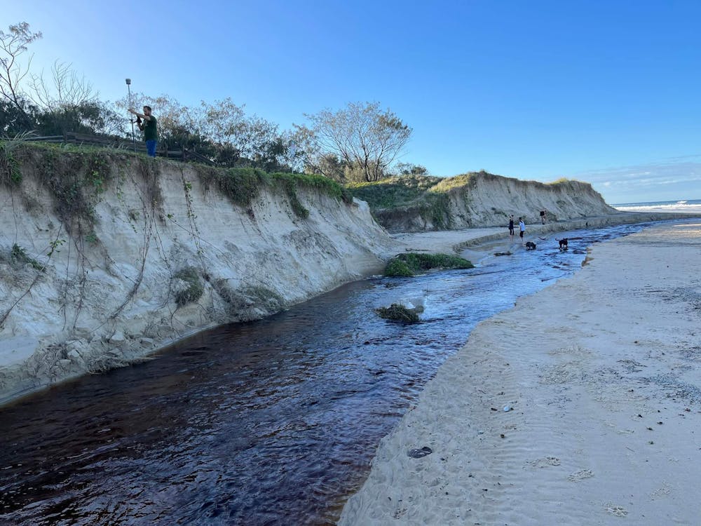 Dune scarps at a beach in Noosa.
Javier Leon, Author provided
Dune scarps at a beach in Noosa.
Javier Leon, Author provided
On the other hand, we can also see that the wet weather has led to greater growth of vegetation on dunes, such as native spinifex and dune bean.
Experiments in laboratory settings show dune vegetation can dissipate up to 40-50% of the water level reached as a result of waves, and reduce erosion[19]. But whether this increase in dune vegetation mitigates further erosion remains to be seen.
A challenging future
The chances of witnessing coastal hazards similar to those in 1967 or 1974 in the coming season are real and, in the unfortunate case they materialise, we should be ready to act. Councils and communities need to prepare ahead and work together towards recovery if disaster strikes using, for example, sand nourishment and sandbags.
Looking ahead, it remains essential to further our understanding about coastal dynamics – especially in a changing climate[20] – so we can better manage densely populated coastal regions.
Read more: Climate-fuelled wave patterns pose an erosion risk for developing countries[21]
After all, much of what we know about the dynamics of Australia’s east coast has been supported by coastal monitoring programs, which were implemented along Queensland[22] and NSW after the 1967 and 1974 storms.
Scientists predict that La Niña conditions along the east coast of Australia – such as warmer waters, higher sea levels, stronger waves and more waves coming from the east – will become the norm under climate change[23].
It’s crucial we start having a serious conversation about coastal adaptation strategies, including implementing a managed retreat[24]. The longer we take, the higher the costs will be.
References
- ^ most of the continent (theconversation.com)
- ^ alerted (www.youtube.com)
- ^ Australia’s rare third (theconversation.com)
- ^ will only exacerbate (theconversation.com)
- ^ La Niña, 3 years in a row: a climate scientist on what flood-weary Australians can expect this summer (theconversation.com)
- ^ forced many (impact.griffith.edu.au)
- ^ record years (www.dailytelegraph.com.au)
- ^ above-average high tides (ro.uow.edu.au)
- ^ dunes to recover (www.jstor.org)
- ^ recent studies (www.nature.com)
- ^ anticlockwise (www.surfline.com)
- ^ north-facing beaches (au.news.yahoo.com)
- ^ Collaroy Beach (www.wrl.unsw.edu.au)
- ^ iconic (www.abc.net.au)
- ^ This is largely (www.nature.com)
- ^ 2022's supercharged summer of climate extremes: How global warming and La Niña fueled disasters on top of disasters (theconversation.com)
- ^ split in two (www.abc.net.au)
- ^ elevation measurements (www.usc.edu.au)
- ^ reduce erosion (www.sciencedirect.com)
- ^ changing climate (www.abc.net.au)
- ^ Climate-fuelled wave patterns pose an erosion risk for developing countries (theconversation.com)
- ^ along Queensland (www.publications.qld.gov.au)
- ^ the norm under climate change (theconversation.com)
- ^ managed retreat (www.usc.edu.au)