We may never be able to predict earthquakes – but we can already know enough to be prepared
- Written by: Hadi Ghasemi, Senior Seismologist, Geoscience Australia
Yesterday’s earthquake in eastern Victoria shook the ground for hundreds of kilometres around and damaged buildings as far away as Melbourne – and took many people by surprise.
While Australia doesn’t compare with seismic hotspots like New Zealand and Japan, relatively small quakes are expected, with Geoscience Australia’s quake tracker[1] listing more than a dozen in the past week alone.
Read more: Melbourne earthquake: what exactly happened, and what's the best way to stay safe from aftershocks?[2]
Even though earthquakes happen all the time, we still can’t predict when the next one will strike, or where, or how big it will be. Unfortunately, we may never be able to make that kind of prediction.
But we can estimate the likelihood of future quakes - and often, that’s enough to make sure our cities are prepared to cope with them.
Why we can’t predict earthquakes
Earthquakes are caused by sudden slips or ruptures in the rock beneath our feet, driven by the movement of the enormous tectonic plates that make up the Earth’s crust.
The exact timing and location of one of these slips are impossible for us to know in advance. Nobody has ever found a reliable and repeatable indicator that a quake is about to happen. We would need a highly detailed model of all the rock everywhere inside the Earth and an understanding of how it responds to tectonic stress to even stand a chance of predicting an earthquake.
However, suppose we understand the large forces driving the tectonic plates and the current level of earthquake activity, and we also study where faults have ruptured in the past. In that case, we can estimate the likelihood that different types of earthquakes might occur in the future.
What we can predict
To calculate the probability of future earthquakes, we look at the seismic activity measured since the development of seismometers about 100 years ago and knowledge of earlier earthquakes from the historical record, and combine these with information about the faults in the Earth’s crust where quakes can occur.
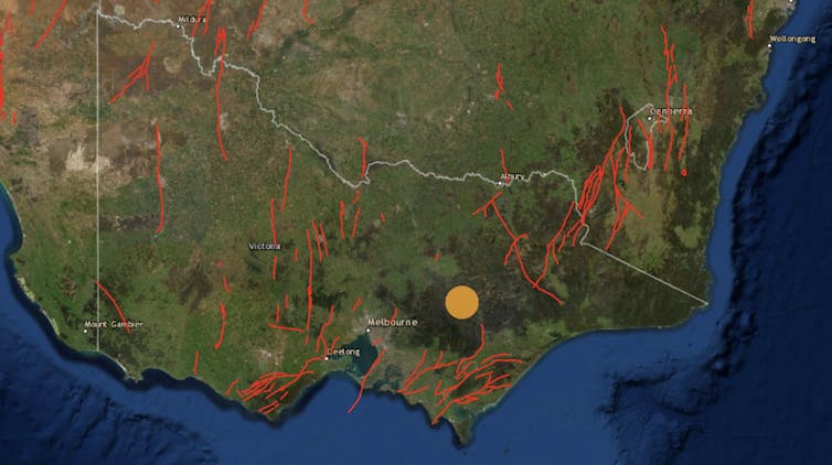
Australia has relatively little seismic activity, but we know there are hundreds of small faults beneath the Australian landmass. These are places where pressure created by the movement of tectonic plates can cause fault rupture or “slip”, which we experience as earthquakes that generate seismic waves and ground shaking.

When we discover a fault, from studying earthquakes or looking at aerial imagery, we often send out teams of geologists to dig trenches across the fault to find traces of past, often prehistoric, earthquake rupture. Depending on the type of signature past earthquakes have left in the soil profile, we can estimate the age and extent of fault movement and develop a history of earthquake activity extending hundreds or often thousands of years into the past.
Identifying prehistoric events is important because the time between large earthquakes on major faults may be longer than the instrumental or even historical record. Without knowledge of prehistoric events, we would have to rely exclusively on the relatively short history of instrumentally recorded earthquakes.
This may cause us to miss the big earthquakes that happen very rarely. We know that longer faults, for example, can usually produce bigger quakes – so if even if we haven’t seen a big quake at a long fault, we know it may be possible in future.
Read more: The earthquake that rattled Melbourne was among Australia's biggest in half a century, but rock records reveal far mightier ones[3]
By combining knowledge of the large earthquake history of nearby faults, and the level of activity of random, smaller earthquakes that may not rupture major faults but occur often enough to be estimated from the instrumental record, we can make a computer model of the likelihood of earthquake occurrence.
For this earthquake occurrence model to be helpful in estimating hazard, we also need to calculate the strength of ground motion generated by each earthquake. This depends strongly on the depth, location, and size of each earthquake.
The ground motion also depends on the properties of rock in the Earth’s crust through which the seismic waves pass, with some rocks absorbing more energy than others. It also depends on the local geology and soil profile near the site of interest, with softer soil leading to stronger ground motion.
Mapping hazards
At Geoscience Australia, we have mapped some of these probabilities in the National Seismic Hazard Assessment[4]. For everywhere in Australia, this map shows the ground motions that may be exceeded over the next 50 years, at certain levels of probability.
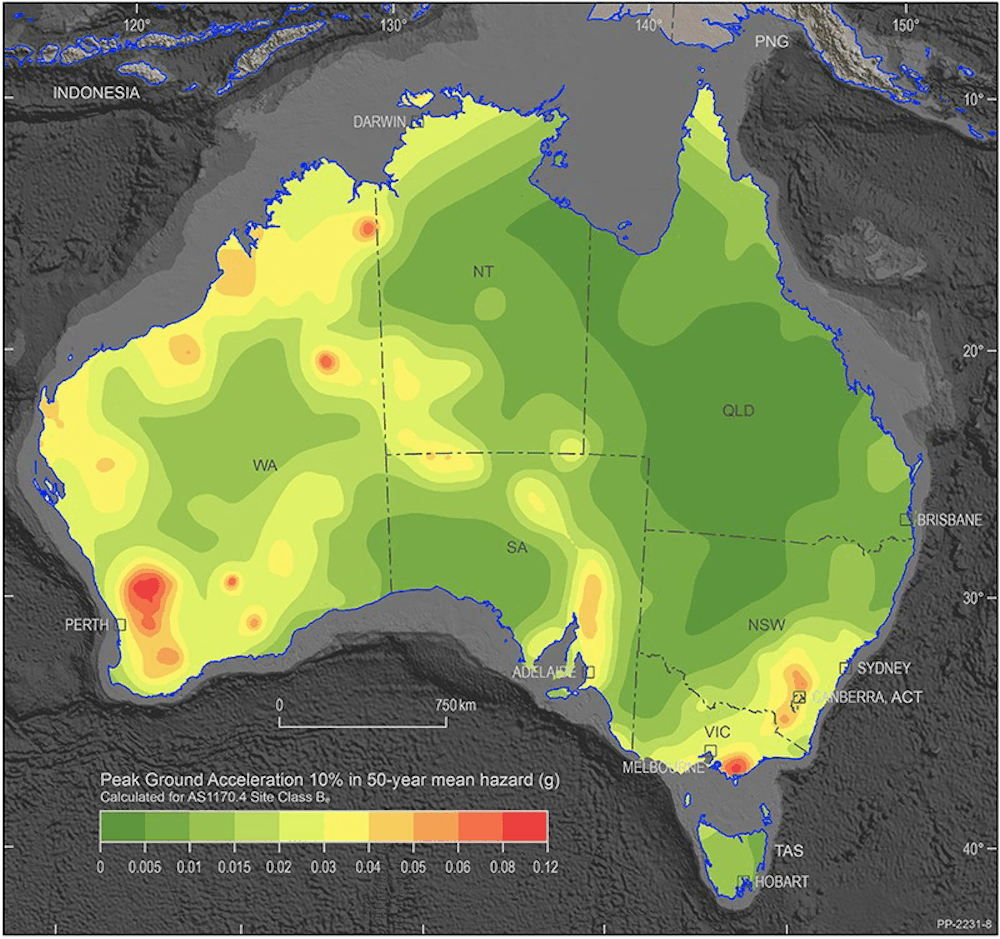 National Seismic Hazard Assessment of Australia map.
Geoscience Australia, CC BY-NC[5]
National Seismic Hazard Assessment of Australia map.
Geoscience Australia, CC BY-NC[5]
This ground motion, usually expressed in terms of a fraction of the acceleration of gravity at the Earth’s surface, is what we call the seismic hazard. Its potential to damage things we value – buildings, for example, or human lives, is what we call “risk”.
From the “risk” point of view, we may not necessarily care if the hazard is high in a place where there are no people, for example, but we may be very concerned if the hazard is high in a big city.
Yesterday’s earthquake is a good example of this: a magnitude 5.9 earthquake in country Victoria is an exciting novelty for most, but the same earthquake occurring in Melbourne would cause huge problems.
Building codes use hazard maps like this to specify how much shaking buildings in an area need to withstand to keep the risk at an acceptable level. Engineers then make sure their buildings are constructed so they won’t fall when they experience the level of ground shaking forecast in the hazard map.
Read more: Earthquakes don’t kill people; buildings do. And those lovely decorative bits are the first to fall[6]
However, until the 1989 Newcastle earthquake, no one realised the Australian building code needed to account for earthquake hazard. Many buildings built before this may be vulnerable even to the level of ground shaking forecast by the hazard map.
An earthquake of magnitude 5.9, if it occurs as far from Melbourne as yesterday’s earthquake did, shouldn’t cause significant damage to buildings that follow the current building code. The fact that it did likely means some buildings are built to a lower standard, and indeed we can see from news photos that many of the damaged buildings look like they were built before 1989.
Insurance companies also use hazard maps to determine the likelihood of damaging earthquakes and set their premiums accordingly.
So, while we can’t tell you where the next earthquake will strike or how big it will be, we can quantify the likelihood of ground motion intensity at the location of interest to make sure we’re all ready for it.
References
- ^ quake tracker (earthquakes.ga.gov.au)
- ^ Melbourne earthquake: what exactly happened, and what's the best way to stay safe from aftershocks? (theconversation.com)
- ^ The earthquake that rattled Melbourne was among Australia's biggest in half a century, but rock records reveal far mightier ones (theconversation.com)
- ^ National Seismic Hazard Assessment (journals.sagepub.com)
- ^ CC BY-NC (creativecommons.org)
- ^ Earthquakes don’t kill people; buildings do. And those lovely decorative bits are the first to fall (theconversation.com)