AI spots shipwrecks from the ocean surface – and even from the air
- Written by: Leila Character, Doctoral student in Geography, The University of Texas at Austin College of Liberal Arts
The Research Brief[1] is a short take about interesting academic work.
The big idea
In collaboration with the United States Navy’s Underwater Archaeology Branch[2], I taught a computer how to recognize shipwrecks on the ocean floor from scans taken by aircraft and ships on the surface. The computer model we created[3] is 92% accurate in finding known shipwrecks. The project focused on the coasts of the mainland U.S. and Puerto Rico. It is now ready to be used to find unknown or unmapped shipwrecks.
The first step in creating the shipwreck model was to teach the computer what a shipwreck looks like. It was also important to teach the computer how to tell the difference between wrecks and the topography of the seafloor. To do this, I needed lots of examples of shipwrecks. I also needed to teach the model what the natural ocean floor looks like.
Conveniently, the National Oceanic and Atmospheric Administration keeps a public database of shipwrecks[4]. It also has a large public database of different types of imagery collected from around the world, including sonar and lidar[5] imagery of the seafloor. The imagery I used extends to a little over 14 miles (23 kilometers) from the coast and to a depth of 279 feet (85 meters). This imagery contains huge areas with no shipwrecks, as well as the occasional shipwreck.
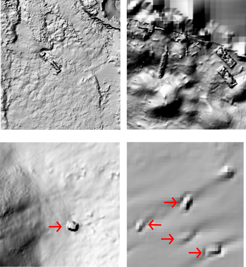 Of these four ocean floor scans, the top two panels clearly show shipwrecks, but the shipwrecks in the bottom two panels, marked by red arrows, could easily be mistaken for natural features.
National Oceanic and Atmospheric Administration
Of these four ocean floor scans, the top two panels clearly show shipwrecks, but the shipwrecks in the bottom two panels, marked by red arrows, could easily be mistaken for natural features.
National Oceanic and Atmospheric Administration
Why it matters
Finding shipwrecks is important for understanding the human past – think trade, migration, war – but underwater archaeology is expensive and dangerous[6]. A model that automatically maps all shipwrecks over a large area can reduce the time and cost needed to look for wrecks, either with underwater drones or human divers.
The Navy’s Underwater Archaeology Branch is interested in this work because it could help the unit find unmapped or unknown naval shipwrecks. More broadly, this is a new method in the field of underwater archaeology that can be expanded to look for various types of submerged archaeological features, including buildings, statues and airplanes.
What other research is being done in this field
This project is the first archaeology-focused model that was built to automatically identify shipwrecks over a large area, in this case the entire coast of the mainland U.S. There are a few related projects that are focused on finding shipwrecks using deep learning and imagery collected by an underwater drone[7]. These projects are able to find a handful of shipwrecks that are in the area immediately surrounding the drone.
What’s next
We’d like to include more shipwreck and imagery data from all over the world in the model. This will help the model get really good at recognizing many different types of shipwrecks. We also hope that the Navy’s Underwater Archaeology Branch will dive to some of the places where the model detected shipwrecks. This will allow us to check the model’s accuracy more carefully.
I’m also working on a few other archaeological machine learning projects, and they all build on each other. The overall goal of my work is to build a customizable archaeological machine learning model. The model would be able to quickly and easily switch between predicting different types of archaeological features, on land as well as underwater, in different parts of the world. To this end, I’m also working on projects focused on finding ancient Maya archaeological structures, caves at a Maya archaeological site and Romanian burial mounds.
References
- ^ Research Brief (theconversation.com)
- ^ Underwater Archaeology Branch (www.history.navy.mil)
- ^ computer model we created (doi.org)
- ^ public database of shipwrecks (nauticalcharts.noaa.gov)
- ^ lidar (oceanservice.noaa.gov)
- ^ underwater archaeology is expensive and dangerous (pages.vassar.edu)
- ^ using deep learning and imagery collected by an underwater drone (doi.org)
Read more https://theconversation.com/ai-spots-shipwrecks-from-the-ocean-surface-and-even-from-the-air-163794