
Coastal dunes are retreating as sea levels rise
- Written by: Patrick Hesp, Professor, Flinders University
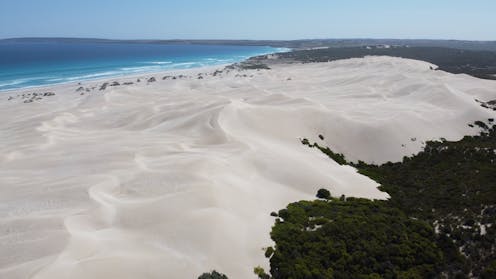
In some parts of Australia, coastal dunes are retreating from the ocean at an alarming rate, as waves carve up the beach and wind blows the sand inland. But coastal communities are largely oblivious to the changes.
Our new research[1] documents the retreat, revealing an accelerating rate of change along Australia’s longest coastal dunefield, in South Australia. These beaches are being reshaped in the geological blink of an eye.
Wave action is eroding the shoreline and the wind is carrying the sand further inland, where new dunes are being formed. Climate change may be accelerating the rate of change[2] by increasing ocean wind speeds and wave heights[3].
This provides yet another reason to reduce emissions and limit global warming – before our beaches and dunes disappear before our very eyes.
Drone footage from Younghusband Peninsula in South Australia (Patrick Hesp)Read more: How rising sea levels will affect our coastal cities and towns[4]
Australia’s longest stretch of coastal dunes
Our South Australian study site, the Younghusband Peninsula, is the longest coastal dune system in Australia. It extends some 190km from the Murray River mouth at Goolwa to Kingston in the state’s southeast.
The shoreline of the central region of the peninsula, near 42 Mile Crossing in the Coorong National Park, started eroding in the early 1980s.
Our new research has found the shoreline has eroded about 100 metres since that time, at an average rate of 1.9m per year. Recently this has become much faster and is now up to 3.3 metres a year. That’s equivalent to losing a tennis court from the front of your house every seven years.
Meanwhile, the dunes are marching inland at an incredible rate of 10 metres a year.
This is an extraordinary rate of change. If the shoreline erosion trend continues, it will dramatically change the national park dune system.
Dune sands may also invade the iconic Coorong Lagoon, impacting the Ramsar-listed wetland of international significance. Sand could slowly fill the lagoon, transforming the environment and reducing the habitat available for fish, waterbirds and other wildlife.

Our research also examined how the shoreline has changed over the past 80 years, using aerial photography and satellite imagery[5], and when the dunes on the Younghusband Peninsula formed, using various dating methods, historical aerial photography from 1945, and satellite imagery. We found they are forming at a very rapid rate.
This new field of coastal dunes developed in just over a decade. The landward edge of the dunefield has moved inland more than 100 metres in eight years.
Three factors may be causing the shoreline erosion and subsequent dune evolution. Offshore reefs that would have protected the coastline have been breaking down. Sea level has been slowly rising since 1920, so higher waves may be reaching the shore. And wave energy has been increasing in the Southern Ocean in the past ten years.
Shaping coastal dunes
Large dune systems are formed by sediment transported by waves from the ocean and the surfzone (where waves break). Once waves deposit the sand on the beach, the wind transports it landwards, creating dunes.
Where large amounts of sediment are delivered to a beach and blown inland, “transgressive” dunes may form. We also examined what drives the development of a transgressive dunefield.
Our research shows there are various factors involved, including:
- high sediment supply from the nearshore and beach system
- rising sea level acting as a marine bulldozer that pushes sediments shorewards
- wave scarping (creating steep, precipitous sand cliffs that are then prone to collapse) followed by wind erosion of dunes at the back of the beach
- climate change resulting in lower rainfall, stronger winds, and a lowering of the water table, which all affect plant growth.
Read more: Climate-fuelled wave patterns pose an erosion risk for developing countries[6]
The eroded area is expanding north and south
Our continuing observations and fieldwork show beach erosion and scarping now extends for several kilometres[7] northwest and southeast of the area near 42 Mile Crossing.
Underlying older dunes are being cannibalised by the wind. As the scarp slope retreats, it supplies sediment that continues building up the dunes[8] and transporting sand landwards across the older dunefield.
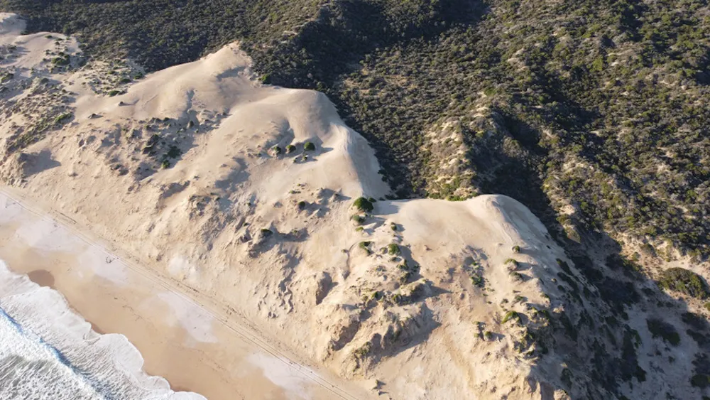 Drone footage shows wave action is forming steep sand cliffs (~12m high). The new sand dunes are cannibalising and migrating over the older vegetated dunes.
Patrick Hesp
Drone footage shows wave action is forming steep sand cliffs (~12m high). The new sand dunes are cannibalising and migrating over the older vegetated dunes.
Patrick Hesp
Drone footage shows how wave erosion of the shoreline combined with wind-driven erosion can trigger the creation of a transgressive dunefield.
Our research shows many of the standard assumptions about the development rates and timescales of dunefield evolution may be wrong. If erosion at this site continues to extend north and south, massive changes to the dunefield system, coastal habitats and possibly the Coorong Lagoon may occur.
Such shoreline erosion and dunefield changes suggest what may happen in future to many Australian beach and dune systems as sea levels continue to rise with climate change.
Flinders University Professor Patrick Hesp talks about his research into coastal dunes.Read more: Become a beach scientist this summer and help monitor changing coastlines[9]
References
- ^ new research (www.sciencedirect.com)
- ^ accelerating the rate of change (theconversation.com)
- ^ ocean wind speeds and wave heights (www.science.org)
- ^ How rising sea levels will affect our coastal cities and towns (theconversation.com)
- ^ aerial photography and satellite imagery (onlinelibrary.wiley.com)
- ^ Climate-fuelled wave patterns pose an erosion risk for developing countries (theconversation.com)
- ^ extends for several kilometres (cmi.ga.gov.au)
- ^ building up the dunes (www.sciencedirect.com)
- ^ Become a beach scientist this summer and help monitor changing coastlines (theconversation.com)