

We're in an El Niño – so why has Australia been so wet?
- Written by Andrew King, Senior Lecturer in Climate Science, The University of Melbourne
After three La Niña summers many of us would have been expecting much hotter and drier conditions this spring and summer after the arrival of El Niño. Instead, in many parts of eastern Australia it’s rained and rained over the last few weeks.
El Niño hasn’t gone away. It’s expected to continue into 2024[1]. Why the rain? Because even with an El Niño, eastern Australia can still experience significant rain events.
Despite the recent rain, Australia’s summer is much more likely than normal to be a hot one.
Has it been unusually wet?
Much of eastern Australia has seen wetter than normal conditions over November. Vigorous low-pressure systems and thunderstorms brought record rain totals and flooding[2] to parts of Victoria, New South Wales and Queensland.
Overall, this meant November was wetter than average across the continent. But as we had a record dry September and a dry October (apart from in eastern Victoria), spring was actually drier than average[3] for Australia as a whole.

Should the recent rain come as a surprise?
When Australians think of El Niño, we usually think of parched soils and blazing sunshine. But this is not guaranteed.
The El Niño of 1997-98, for instance, was one of the strongest on record. Even so, the spring of 1997 was actually a bit wetter than normal[4] over parts of South Australia, NSW and southern Queensland.
The El Niño-Southern Oscillation describes changes in the tropical central and east Pacific. These changes can swing between El Niño, neutral and La Niña events. Think of poet Dorothea Mackellar’s description “of droughts and flooding rains” – that’s the type of contrasting extremes that El Niño and La Niña often cause.
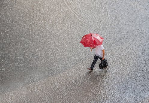
 Rainy El Niño? Just wait – the heat will return.
Dan Himbrechts/AAP
Rainy El Niño? Just wait – the heat will return.
Dan Himbrechts/AAP
It’s not as simple as El Niño hot and dry, La Niña cool and rainy. The influence of this phenomenon is complex and non-linear.
Read more: Faster disaster: climate change fuels 'flash droughts', intense downpours and storms[5]
Scientists are more confident in saying La Niña causes unusually wet conditions over eastern Australia than we are in saying El Niño causes unusually dry conditions. That’s because Australia is typically a dry place and just a few wet days can make a big difference to whether a month or season is wetter or drier than average.
When El Niño events are coupled with a second climate driver, a positive Indian Ocean Dipole[6] – where colder water comes up from the deep in the eastern Indian Ocean – we typically see fewer low pressure weather systems causing heavy rainfall over southeastern Australia.
But again, nothing is certain, as we’ve seen. Despite these two climate cycles suggesting less rain was likely, the rain returned.
Why? One reason is the unusually high sea surface temperatures to the south and southeast of Australia[7], which can drive more moisture into the air and trigger more rain in the region.
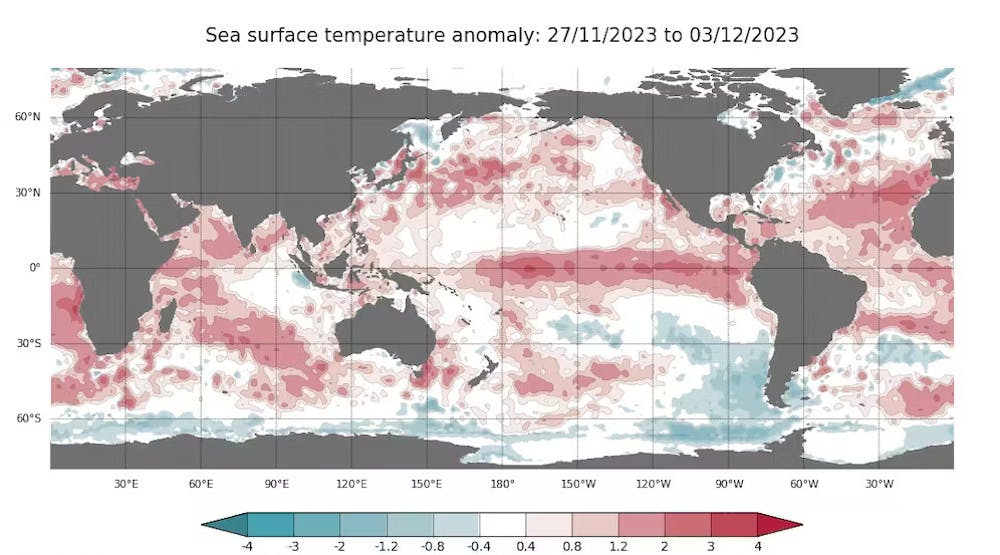 Sea surface temperatures are unusually high around southern Australia as well as in the central and eastern tropical Pacific where the El Niño event is continuing.
Bureau of Meteorology, CC BY-ND[8]
Sea surface temperatures are unusually high around southern Australia as well as in the central and eastern tropical Pacific where the El Niño event is continuing.
Bureau of Meteorology, CC BY-ND[8]
Many of us were shocked by how intense late November’s rainfall was. But this is a feature of how variable and fickle Australia’s weather can be.
During El Niño events we should still be prepared for floods even if droughts are more likely on average. You might think we would see more thunderstorms during, say, a La Niña event. In fact, that’s not true. Thunderstorms do not have a strong relationship[9] to either of these climate cycles. That matters, because it’s thunderstorms which can drive many of these heavy rain events we see during spring in Australia.
What does the summer hold?
During spring, El Niño in the Pacific and conditions in the Indian Ocean typically have their strongest effect on Australia. In December, these influences start to wane as Indian Ocean Dipole events usually begin to decay as we move into summer.
In the summer, more rain falls in small-scale weather systems such as thunderstorms which makes seasonal outlooks less accurate[10] compared to other times of the year. At present, our seasonal prediction models have a limited ability to simulate thunderstorms.
But we can still make some predictions about the summer ahead. We usually see fewer tropical cyclones during El Niño summers, noting that tropical cyclones can cause extreme rainfall in northern Australia. The seasonal outlook[11] reflects this, with an 80% chance of a below-average number of tropical cyclones.
What about fire? The recent rains are good news in that they should help reduce the chance of major forest fires in parts of southeast Australia for a while at least, while noting many other factors also contribute to fire risk. However, grass fires could become more likely in some regions, as grass grows fast after rain and can dry out quickly if hot and dry weather returns.
Our overall bushfire outlook[12] points to a heightened fire risk through much of the east of Australia. There have already been severe fires near Perth[13] leading to loss of property. It’s very early in the fire season for southern Western Australia to see major fire damage like that.
Earlier in spring we saw flash droughts[14] start to form. That’s where soils rapidly dry out under hot and sunny conditions.
Where sustained dry conditions return, we could see flash drought conditions follow soon after.
Our high water storage levels mean major droughts and water restrictions like those seen in the 2001-2009 Millennium Drought won’t return for a while longer in the southeast.
As with every summer in Australia, we must be prepared for extreme weather including fire, floods and intense heat. Human-caused climate change is supercharging our extreme weather events[15] and making our summer weather more dangerous than it used to be.
Read more: In September we went past 1.5 degrees. In November, we tipped over 2 degrees for the first time. What's going on?[16]
References
- ^ continue into 2024 (www.cpc.ncep.noaa.gov)
- ^ flooding (www.abc.net.au)
- ^ actually drier than average (www.bom.gov.au)
- ^ bit wetter than normal (www.bom.gov.au)
- ^ Faster disaster: climate change fuels 'flash droughts', intense downpours and storms (theconversation.com)
- ^ positive Indian Ocean Dipole (www.bom.gov.au)
- ^ southeast of Australia (theconversation.com)
- ^ CC BY-ND (creativecommons.org)
- ^ do not have a strong relationship (doi.org)
- ^ seasonal outlooks less accurate (rmets.onlinelibrary.wiley.com)
- ^ seasonal outlook (www.bom.gov.au)
- ^ bushfire outlook (www.afac.com.au)
- ^ severe fires near Perth (www.theguardian.com)
- ^ flash droughts (cosmosmagazine.com)
- ^ supercharging our extreme weather events (theconversation.com)
- ^ In September we went past 1.5 degrees. In November, we tipped over 2 degrees for the first time. What's going on? (theconversation.com)
Read more https://theconversation.com/were-in-an-el-nino-so-why-has-australia-been-so-wet-219111