Cyclone Alfred is expected to hit southeast Queensland – the first in 50 years to strike so far south
- Written by: Steve Turton, Adjunct Professor of Environmental Geography, CQUniversity Australia
If you’re in southeast Queensland, brace yourself.
Tropical Cyclone Alfred is expected[1] to cross the southeast Queensland coast late this Thursday as a Category 2 storm[2]. The last tropical cyclone to make landfall in the region was ex-Tropical Cyclone Zoe[3] in 1974, half a century ago.
Category 2 cyclones produce winds at levels considered damaging at best, destructive at worst – typically gusting as high as 164 kilometres per hour. It can cause minor damage to houses and significant damage to signs, trees and caravans. Power failures are common, while small boats can break moorings. Significant beach erosion is likely on the Sunshine Coast and Gold Coast.
Cyclone Alfred formed[4] nine days ago in the Coral Sea, 900 kilometres north east of Cairns, then headed out to sea. Then it tracked south, reaching severe Category 4 status east of Mackay. In recent days, the storm weakened further as it meandered into the cooler waters[5] of the southern Coral Sea. The cyclone seemed set to peter out, far offshore.
No longer. The latest forecasts show the storm sharply changing direction and making a beeline for heavily populated areas of southeast Queensland.
Its erratic path is not unexpected. Cyclones forming over the Coral Sea have the most unpredictable paths in the world[6], frustrating coastal Queensland residents, fishers, tourist operators and meteorologists themselves.
Alfred is a typically unpredictable Coral Sea cyclone. But unusually, it has maintained its cyclonic structure and intensity much further south, into subtropical latitudes.
Cyclones, typhoons and hurricanes explained
Cyclones, hurricanes and typhoons are different names for the same intense, horizontally rotating tropical storms. They occur in seven tropical ocean basins[9], above and below the equator.
These storms need atmospheric heat. They only form over seas warmer than 27°C, where evaporation rates are high. They don’t occur in the cooler South Atlantic basin, and only rarely in the southeast Pacific, during strong El Niño events[10] when sea surface temperatures are warmer.
The northwest Pacific – off eastern Asia and the Philippines – experiences the most frequent and intense tropical storms (known there as typhoons).
Australia averages about 13 cyclones a year. Most won’t make landfall and only a few are severe. The world’s hardest hit nation is China[11], where six cyclones make landfall annually.

In the north Pacific and north Atlantic, cyclones typically follow predictable tracks. They move westwards, steered by sub-tropical high pressure sytems[14] to their north.
Cyclone paths are also fairly predictable off the northwest coast of Australia. They typically form over the Timor Sea and drift southwest before shifting south and crossing the coast. Some are severe, as we saw with Category 5 Cyclone Zelia[15] last month.
By contrast, Coral Sea cyclones such as Alfred are much harder to predict.
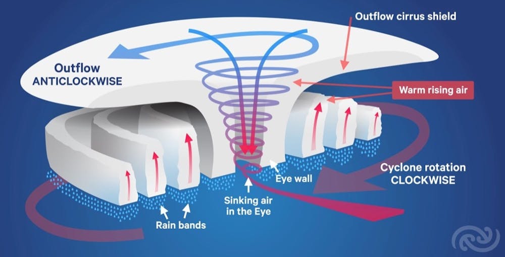 In the southern hemisphere, cyclones spin clockwise. This figure shows how cyclones form around a low pressure system over warm seawater. Depending on their intensity, tropical cyclones are steered by dominant winds in the lower, middle and upper layers of the atmosphere. Metservice New Zealand, CC BY-NC-ND[16][17]
How cyclones are steered
Strong winds are the main force steering cyclones, determining direction and forward speed.
Severe tropical cyclones (categories 3–5) are characterised by deep convection currents, which form the famous eye[18] at the centre of the storm, as well as feeder rainbands converging into their centre. Severe systems are generally steered by winds in the middle to upper levels.
By contrast, weaker cyclones (categories 1–2) are much shallower and often have little or no convection around their centre. They tend to be steered by winds in the lower to middle levels. At present, Cyclone Alfred looks to remain relatively weak.
Wind speed and direction can differ markedly in different levels of the atmosphere. Winds can also change direction at the same level. These competing influences are what lies behind the erratic paths of our cyclones.
Cyclones forming in the Coral Sea are more likely to be pushed in different directions by different winds and weather systems than their equivalents in other ocean basins. This is what makes them so hard to predict.
In our region, cyclones are largely steered[19] by two high pressure systems.
The first pushes cyclones east, and the second steers them west. If both are present and roughly equal in strength, they can hold a cyclone near-stationary. We saw this with Cyclone Alfred for most of the last week.
Cyclone Alfred is now forecast to strengthen and head towards land.Slow-moving tropical cyclones such as Alfred are more likely to wander, while faster-moving cyclones such as Severe Cyclone Yasi[20] follow a stronger steering pattern and more predictable paths.
Quite often, cyclones travel south and east out to sea[21]. There, they quietly die in a large area of ocean colloquially known as the cyclone graveyard, southeast of Brisbane. These cyclones are steered by different weather systems – upper troughs[22], cold masses of air from the Southern Ocean.
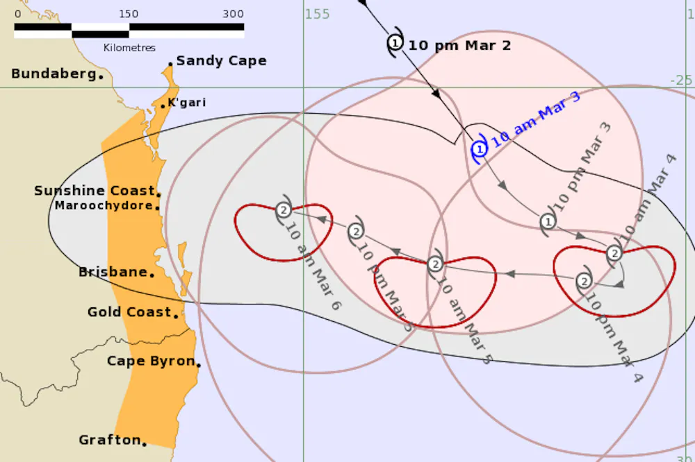
Cyclone Alfred was initially steered east by a near equatorial ridge to its northeast, then became stuck between this high pressure ridge and a sub-tropical ridge to its southwest. This is why it meandered very slowly south and built up strength to become severe.
An upper trough then pushed it southeast over the weekend. This week, it’s likely to turn sharply westward towards land, propelled by a high pressure ridge to the south.
Landfall – but where?
After meandering around the Coral Sea for more than a week, Cyclone Alfred’s forecast track now seems more certain.
The system is expected to intensify from a Category 1 to 2 tomorrow as it moves over warmer waters and draws in more moisture-laden air. This should see it maintain near Category 2 status until landfall. After it hits, it should rapidly weaken to a tropical low over southern Queensland into the weekend.
Alfred will bring a lot of rain, making flooded rivers and flash flooding likely. The Bureau of Meteorology has issued a flood watch for catchments all the way from Maryborough to the Northern Rivers area of New South Wales. These communities should prepare now.
Cyclone Alfred has a large area of gales, so will affect a wide swathe of coastline from K'gari (Fraser Island) to Byron Bay. Storm-force winds will cover a 100km wide area, mostly concentrated on its southern flank as it approaches and crosses the coast.
In the longer term, Alfred’s remnants will likely be captured by an approaching upper trough and taken back offshore, where it will die in the cyclone graveyard – gone, but not likely to be forgotten.
References
- ^ expected (www.abc.net.au)
- ^ Category 2 storm (www.bom.gov.au)
- ^ ex-Tropical Cyclone Zoe (www.bom.gov.au)
- ^ formed (www.abc.net.au)
- ^ cooler waters (www.bom.gov.au)
- ^ unpredictable paths in the world (journals.ametsoc.org)
- ^ Bureau of Meteorology (www.bom.gov.au)
- ^ CC BY-NC-ND (creativecommons.org)
- ^ seven tropical ocean basins (esajournals.onlinelibrary.wiley.com)
- ^ strong El Niño events (www.climate.gov)
- ^ is China (www.sciencedirect.com)
- ^ NASA (earthobservatory.nasa.gov)
- ^ CC BY-NC-ND (creativecommons.org)
- ^ sub-tropical high pressure sytems (www.ncei.noaa.gov)
- ^ Cyclone Zelia (theconversation.com)
- ^ Metservice New Zealand (www.sciencemediacentre.co.nz)
- ^ CC BY-NC-ND (creativecommons.org)
- ^ eye (en.wikipedia.org)
- ^ largely steered (journals.ametsoc.org)
- ^ Severe Cyclone Yasi (www.bom.gov.au)
- ^ out to sea (journals.ametsoc.org)
- ^ upper troughs (www.bom.gov.au)